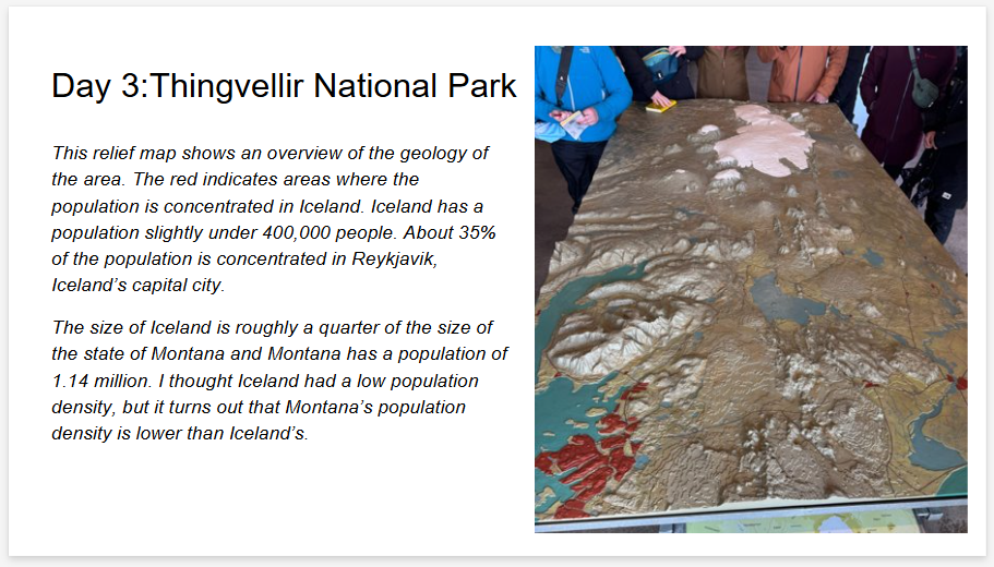
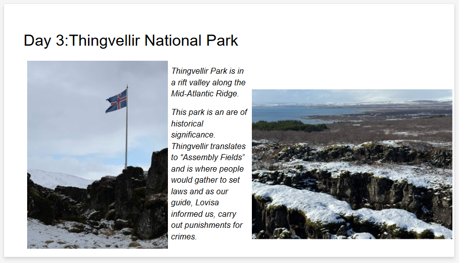
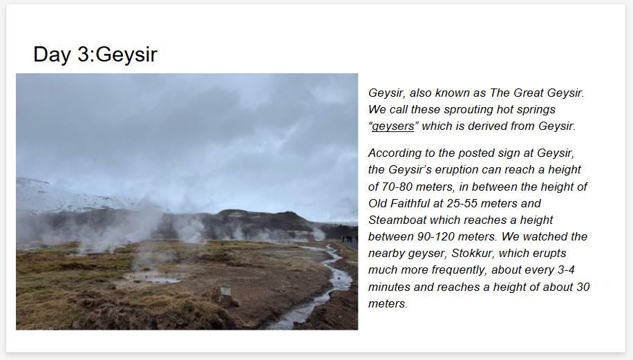
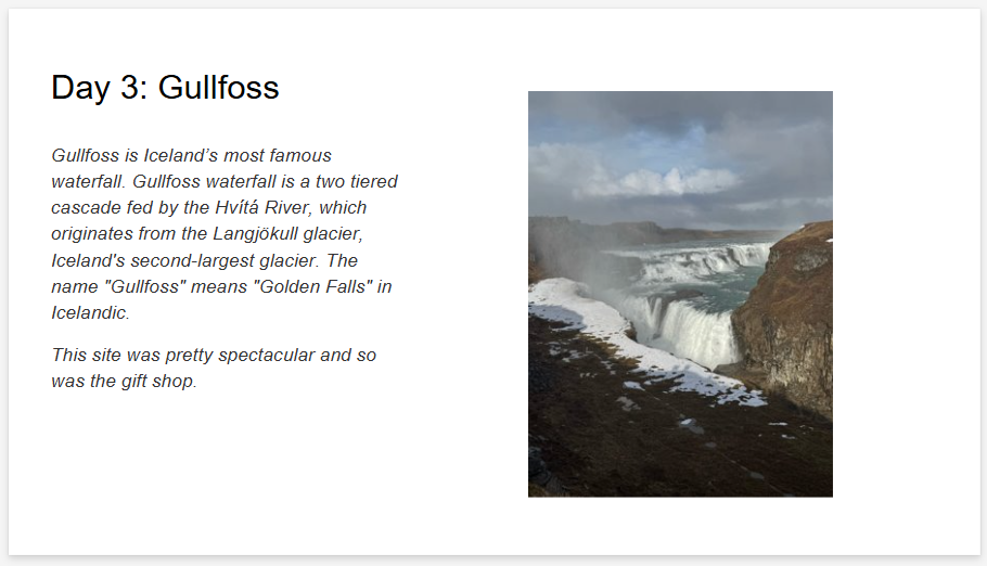
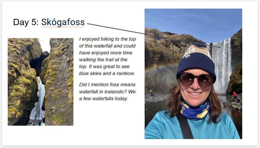
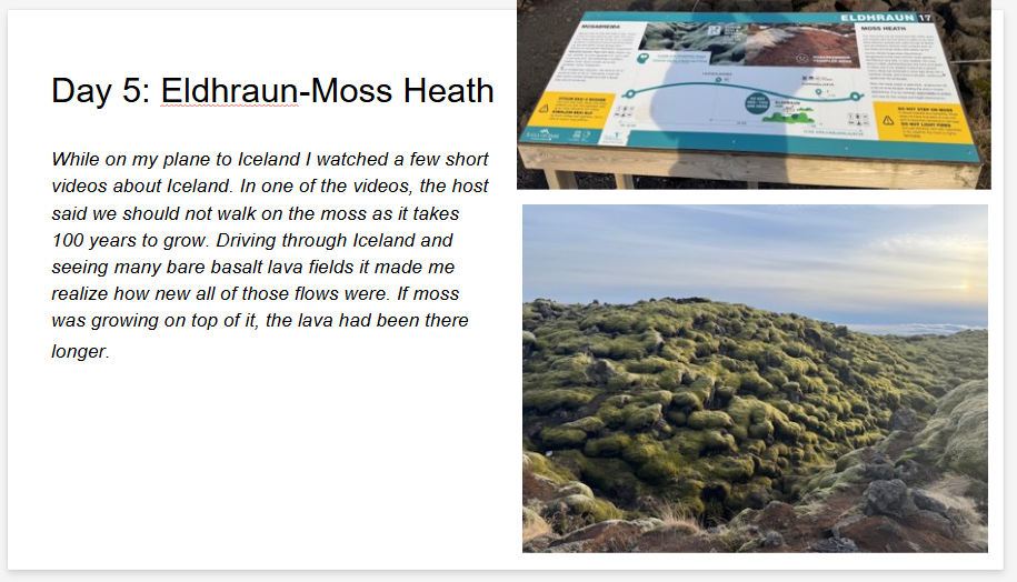
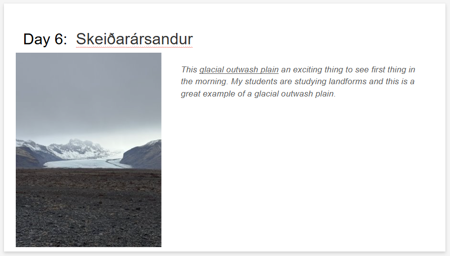
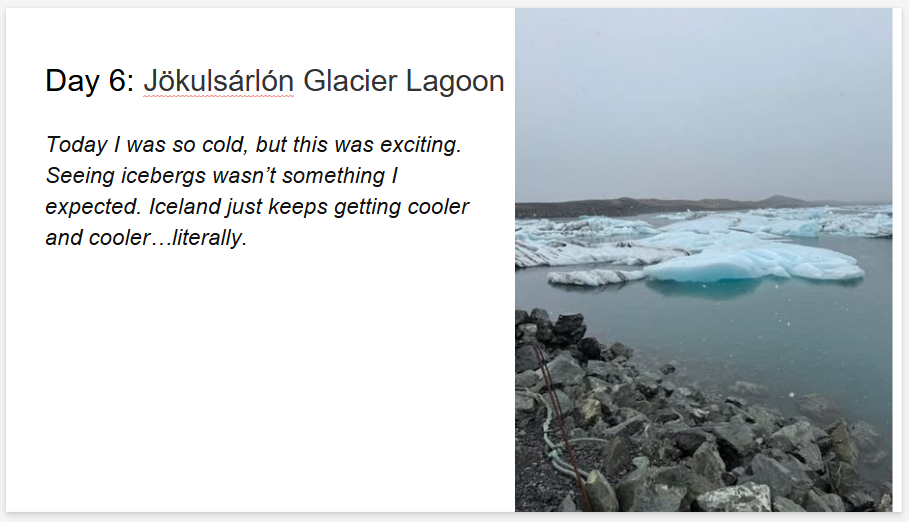
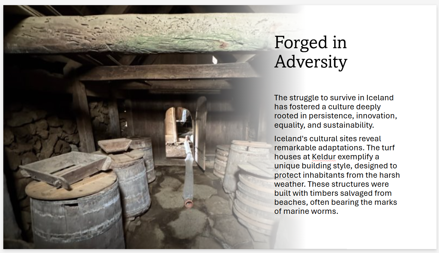
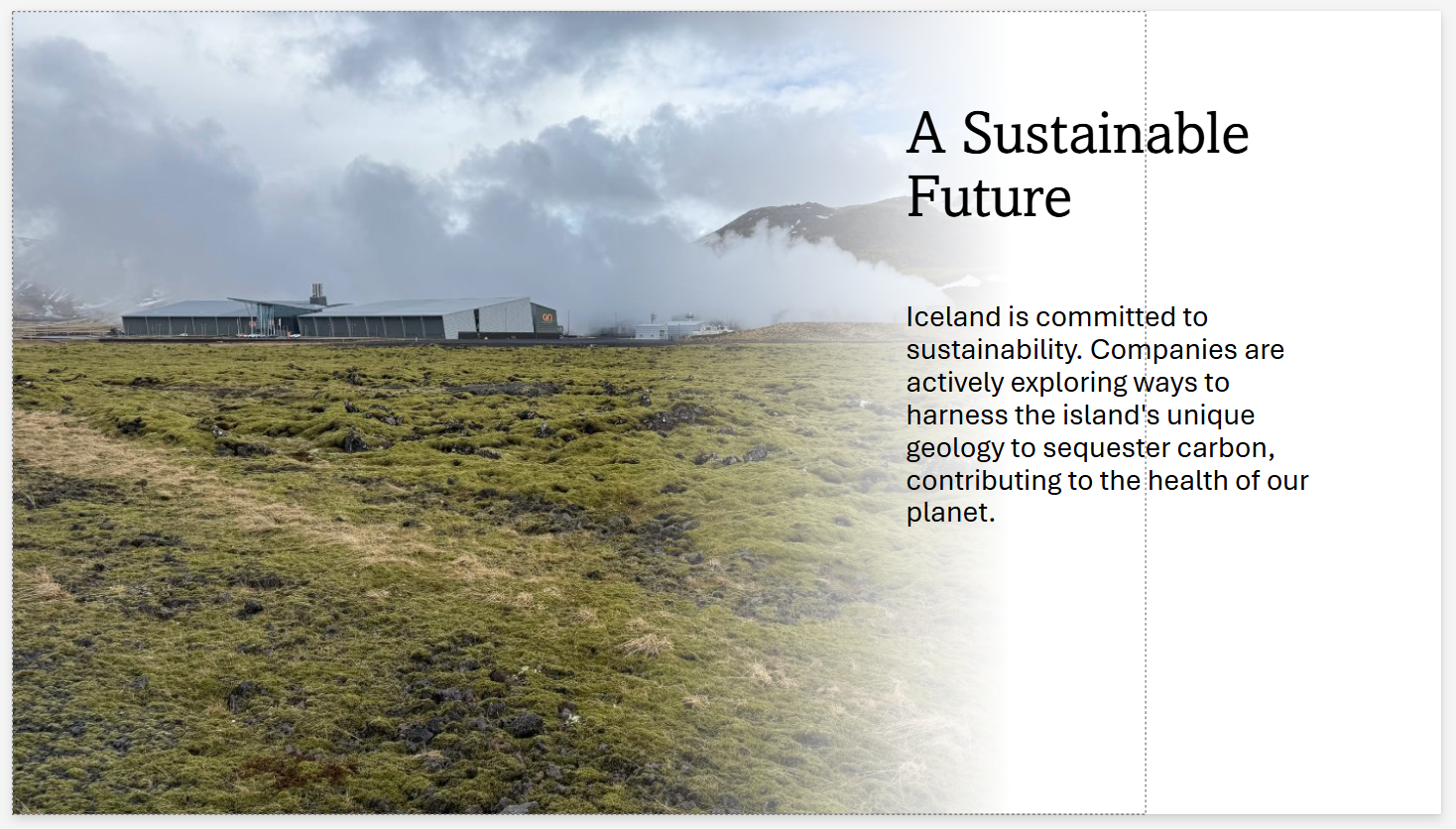
Iceland Instructional Resources
Table of Contents
Greg Anderson
Megan Blauwkamp
Amy Brown
William Cochran
Rhi Flemming
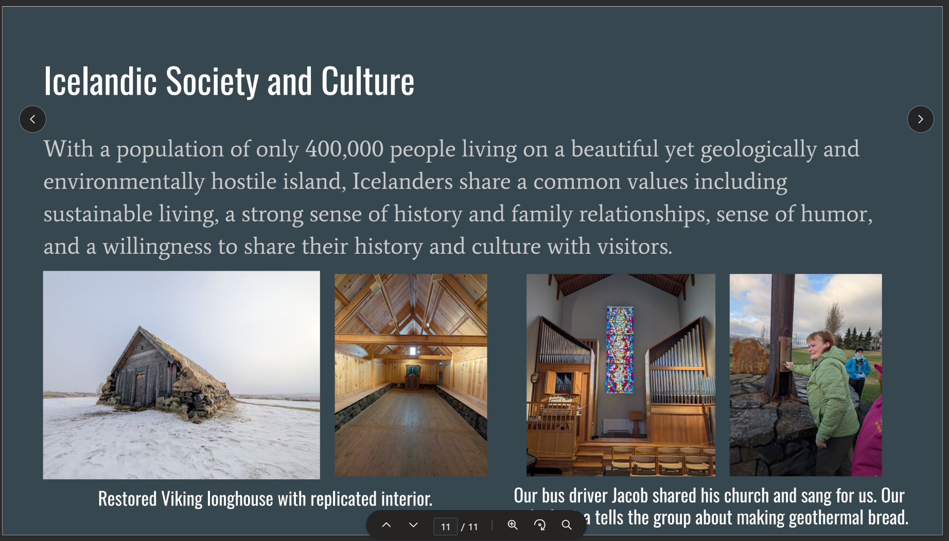
Michael Lee
Tegan Mortimer
Patrice Rex
Ken Sperling
Donna Tully
Dan Vasquez
Annie Wentz
Cheyenne Winchester
Greg Anderson
Describing and Classifying Soils Paper
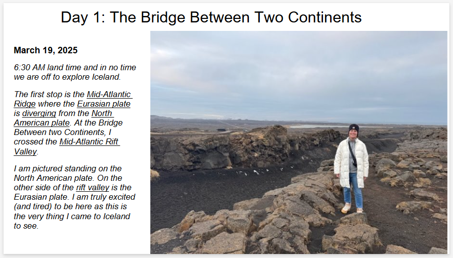
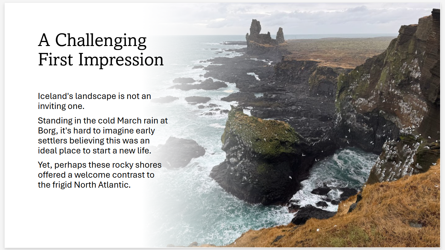
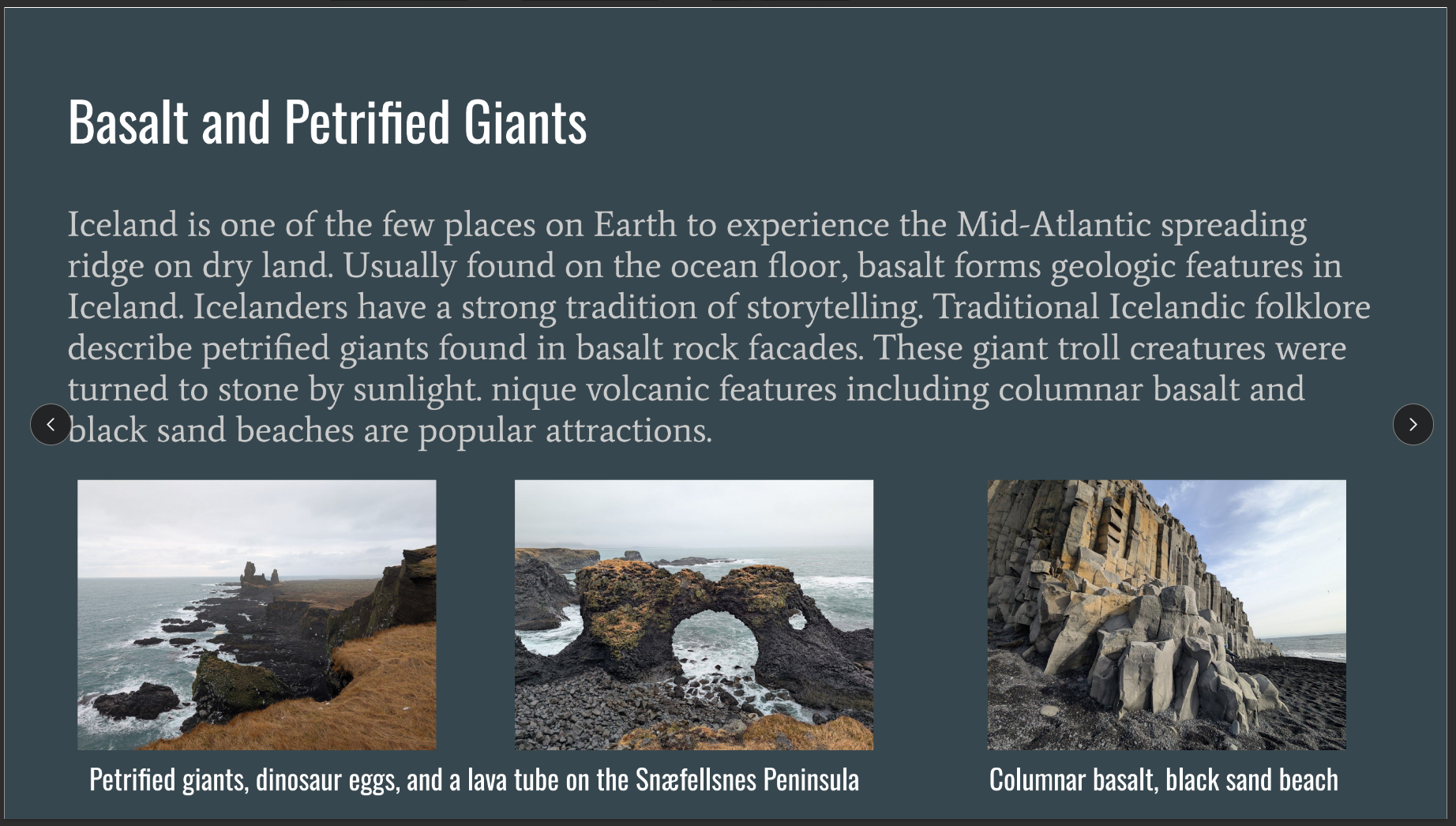
Introduction: Case Study on CLORPT Factors in Iceland
Soil formation has a direct relationship to where you live. Soil forms from climate, organisms, relief, parent material and time (CLORPT). Initial formation of soil is a direct result of the breakdown of parent material or the deposition of a material over parent material.
Soil scientists identify CLORPT factors as either active or passive factors. Climate and organisms are identified as “active” factors of soil formation because their influence over soil development can be directly observed over a short period of time. For example, rain, heat, cold, wind, microorganisms (algae, fungi), earthworms, and burrowing animals can be directly observed influencing soil development. Passive factors such as time, topography, relief, and parent material are noted as “passive” factors because their effects are not immediately observed. Passive factors can, however, influence how climate and organisms affect soil development and formation.
Climate
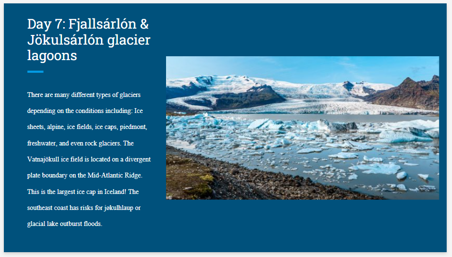
Iceland is a dynamic Nordic Island country located in the North Atlantic. The striking land features are formed by active geological processes, from divergent plate boundaries, volcanism, and earthquakes. Iceland is covered by roughly 11% continental glaciers. Striking coastlines with black beaches and cliffs surround the island. The landmass of Iceland is 39,769 mi2 and is comparable to the state of Kentucky 39,732 mi2. For comparison Kentucky’slandmass is ranked 36th out of the 50 United States.
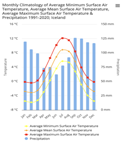
Figure 1: Iceland Average Climatology 1991-2020
Despite its name Iceland is not completely covered in ice. The climate in Iceland has an average surface temperature of 5.57 ℃ (42℉) and average precipitation of 120.93 mm (4.71 in) per year from 1991 to 2020 (Figure 1). Precipitation is greater in the winter compared to the summer months. The southern part of Iceland is much warmer, wetter, and winder compared to the North. The central part of Iceland is called the central highlands and has the highest elevation along with continental glaciers. More precipitation occurs in the highlands compared to the lower elevations. The Source: https://climateknowledgeportal.worldbank.org/country/iceland/climate-data-historical
Northern latitude of 64 degrees interacts with polar and arctic wind and pressure, subjecting the country with changing weather conditions. These weather conditions interact with high altitude glaciers and terrain, leading to windy conditions, soil erosion, and poor soil development.
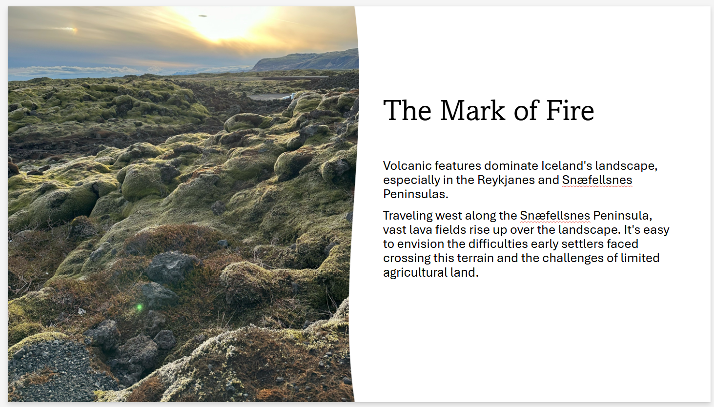
Parent Material
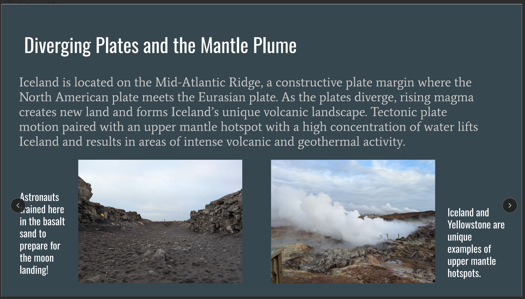
The primary parent material in Iceland is ballistic rock from lava flows. Iceland is located on the Mid Atlantic spreading ridge, which means that roughly half of the country is on the NorthAmerican plate and the other half is on the Eurasian plate. The Mid Atlantic ridge is spreadingridge moving Iceland in two different directions. As the country is moving in two different directions, this creates a divergent rift boundary. The spreading pulls apart the land creating a valley floor below a high plateau area. In geology this is termed a horst and graben structure. As a block of earth falls this is termed the graben and a block of earth rises is termed the horst. In Iceland the divergent spreading is an example of symmetrical seafloor spreading meaning that both the North American and Eurasian plate move away from each other at the same rate.
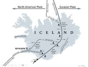
Figure 2: North American and Eurasian Plate
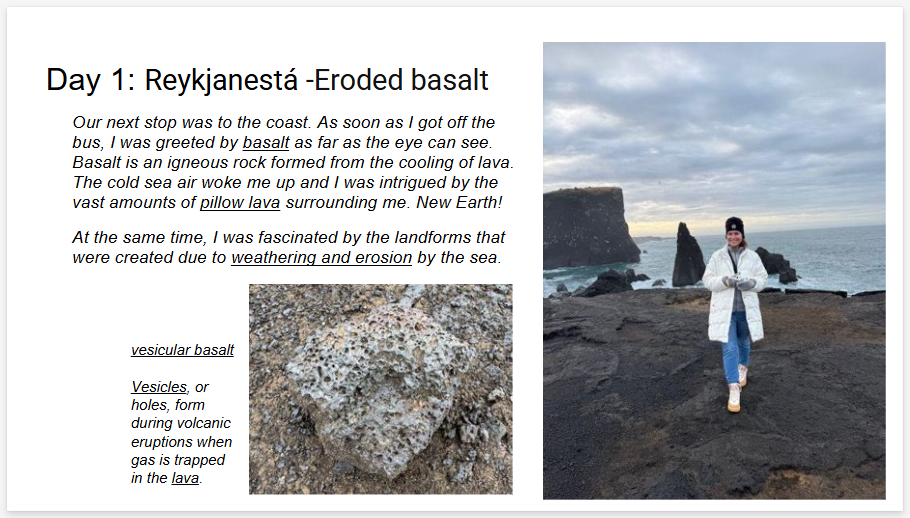
As the plates move away from each other, magma arises from the upper mantle as gabbro, and is excreted to the surface as basalt. As the island mass is moving into two different directions this creates three volcanic zones in Iceland (Reyjanic, East and North volcanic zones) that sit on the Mid Atlantic spreading ridge. These three zones have the most volcanic activity within the country. Between the Reyjanic and the East and North volcanic zone are two transform offsets which create seismic zones between the Mid Atlantic spreading ridge. These active volcanic zones reshape the landscape through volcanic eruptions releasing volcanic ash (tuff) and magma.
The basaltic lava field is in Eldhraun Iceland as a result of the Laki eruption of 1783-84 (Figure 6). Basalt has a black/grey color and is an extrusive, mafic (igneous rock high is iron and magnesium), igneous rock (cooling of magma). Basalt is categorized as a hard rto very hard rock and is one of the most one of the abundant rock types on Earth that drive from volcanic eruptions or seafloor spreading zones. Basalt has low silica content and has low viscosity. The low viscosity of basalt allows for it to flow easily. Surface lava flow can be categorized into two different types:
- Pāhoehoe – Lava flows with smooth, billowy, or ropy surfaces
- ‘A‘ā – Lava flows with rough, jagged, or clinker surfaces
The Eldhraun volcanic field is the largest sheet volcanic field in Iceland. Sheet volcanic fields can be categorized as both Pāhoehoe or‘A‘ā type flows. Sheet volcanic fields form from large eruptions, have a high viscosity, that move over a flat surface area. High cooling of the lava field coalesces (make the lava form back together as one piece) the moving lava.
Time: Weathering Erosion and Deposition
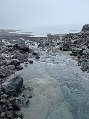
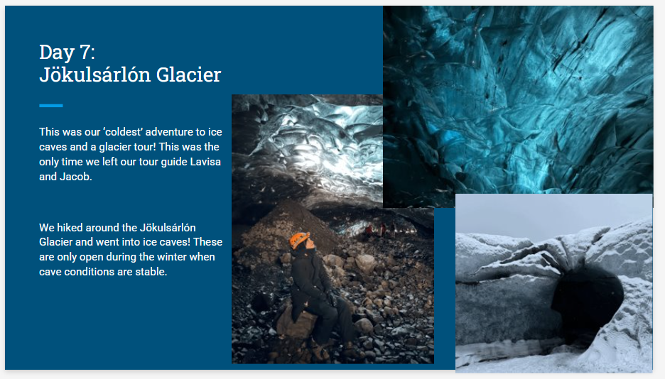
Figure 3: Jokulsarlon Glacier
Mechanical weathering is the breakdown of parent material by a physical process. The Jökulsárlón Glacier water runoff demonstrates mechanical water weathering occurs in two different ways. Running water weathering occurs as water runs over a rock slowly carrying sediments over a rock, slowly rubbing against the parent and eroding the material as seen in (Figure 3). If liquid water freezes in the cracks of a rock, water expands which fractures the parent material into smaller pieces. This can be observed in the background of (Figure 3) with the continental glacier as it warms up and freezes over the rocks, fracturing the rocks and breaking them down into smaller pieces.
Erosion occurs as the material is weathered and moved from an original location to a new location by a natural process. The water flowing from the glacier moves sediments down the stream (Figure 3) shows erosion. Eventually the sediments will stop flowing and eventually settle(deposition).
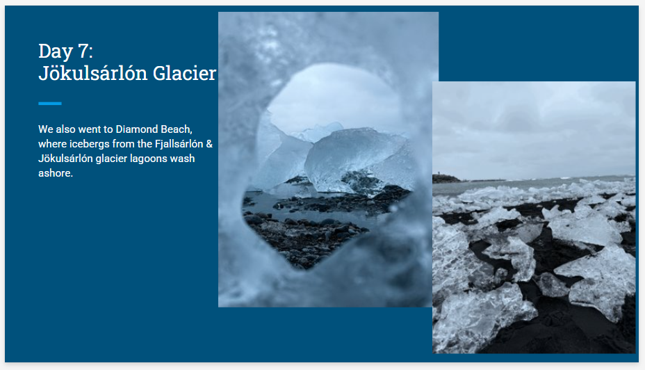
Soil particles or parental material that are deposited to an area are transported to an environment from another environment can add depth to a soil profile. Transportation can be from wind, water, gravity, or glaciers. In the picture of Eldhraun (Figure 6) wind can pick up soil particles and deposit small sediments to the area on top of basaltic parent material. Over time, these sediments can add depth to the soil profile.
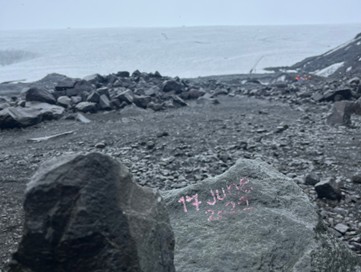
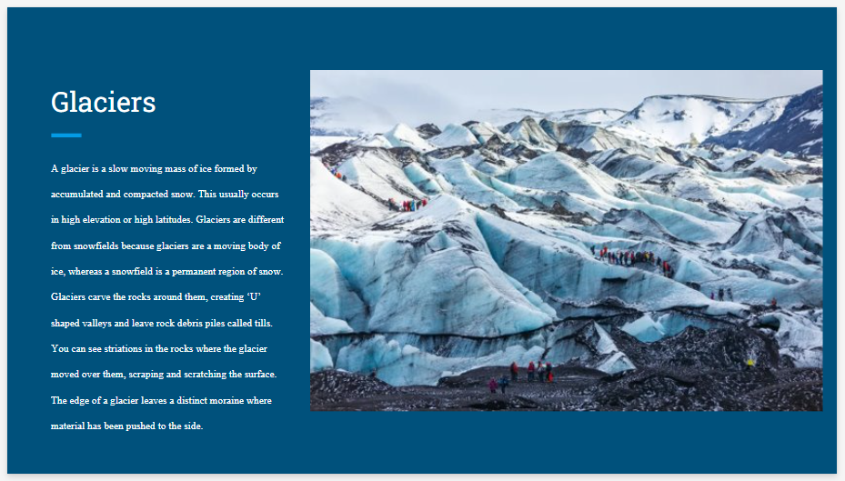
Figure 4: Jokulsarlon Glacial Trail
Glacial till (small, unsorted rock deposited from glacial retreat) is unconsolidated sediments that have been transported from one place to another. The glacial till (Figure 3) is from the largest glacier in Iceland. The erratic (larger bolder size rocks deposited from glacial retreat) in the forefront dates June 17th, 2022. From the erratic to the glacier in the background illustrates the amount of deposition that has occurred since June 17th, 2022.
Over time, soil is able to develop in thickness leading to distinct soil layers. Iceland however has poor soil development since volcanos, deposit tuff, and lava destroy soil and create a hardened rock layer. Creating a mature soil with different horizons takes thousands to millions of years to develop.
Climate (temperature and precipitation) influences the types of plants and animals that live in a geologic region. The climate influences weathering and deposition rates, chemical and physical relationships within soil which can increase or decrease soil development rates. Higher latitudes like Iceland have colder temperatures, decreased biodiversity, shorter growing seasons, and decomposition rates. This is typically the opposite as latitudes near the equator.
Relief
Relief refers to the topography of the land. For being such a small landmass, Iceland has dramatic topography from beaches, mountains, rift valleys, fjords, lava fields, hot springs, glaciers, and volcanic plateaus.
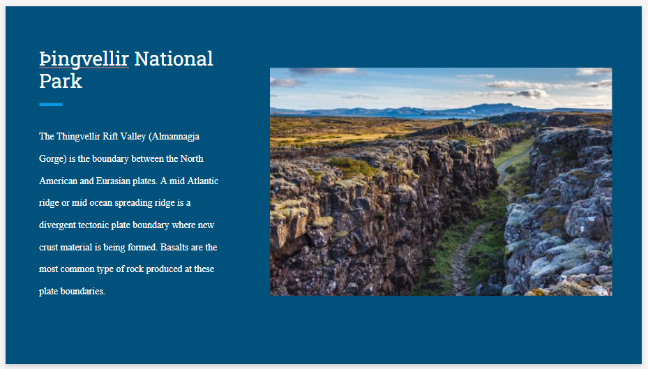
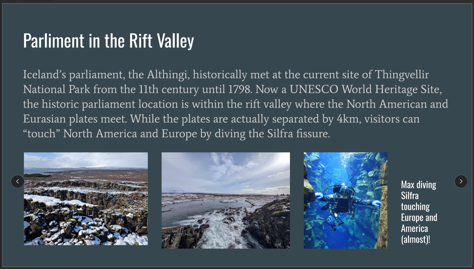
The rift valley in Thingvellir National Park affects drainage and runoff of soil sediments (Figure 5). The divergent boundary creates a void with a slope running downward from the plateau to the void on both plate boundaries. The slope allows for gravity to carry sediments and water to flow down the slope into the void.
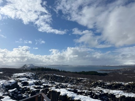
Figure 5: Thingvelir National Park
Figure 5 shows Thingvellir National Park in which the divergent plate boundary created a rift valley between the North American and Eurasian plates. As the valley separates the two plates about the valley floor separates into a horst and graben geologic structure. The forefront of Figure 5 depicts a horst and graben structure leading down into the Thingvellir Lake. Thingvellir lake is the largest lake in Iceland and is 84 km2. The lake fills in the divergent plate rift. Figure 5 was taken on the Eurasian plate looking at the North American plate. On the opposite side of the lake the horst and graben structure is also present leading up to the plateau.
Organisms
Eldhraun lava field has the beginnings of soil development. After the lava moves over the area destroying the soil and all plant life, the magma cooled forming the sheeted basaltic rock (Figure 6). Notice the moss and lichen growing on top of the lava field that was created over 240 years ago. The first development of soil is from lichen. Lichens are soil pioneers that can grow on the surface of ballistic rock without a soil layer. Lichen has a complex relationship between fungus and algae leading them to grow on surfaces such as basalt. Lichen is a fungus that anchors itself onto the rock and can grow through algae development on top of the fungus, acting as a symbiotic relationship. Lichens are about to physically and chemically weather the basaltic rock. We have already discussed how physical weathering occurs. Chemical weathering occurs when a chemical can weather and/or erode a substance. An example of chemical weathering with ballistic rock is the lichens produce a weak acid (oxalic acid), CO2 release in water creating carbonic acid, and biochemical compounds, leading to the erosion of rocks and formation of mineral compounds.
Over time lichen, decay, and deposition will produce enough soil for mosses to start to grow. The moss's roots will slowly infiltrate the porous basalt breaking it down into smaller pieces. As the moss dies and macro and microorganisms decompose this organic material will add depth to the soil profile. Over time, more and more soil will develop leading to greater soil depth and the ability for other plants to grow.
Figure 6: Eldhraun Ballistic field from Laki eruption 1783- 1784
Plants, animals, and macro/microorganisms facilitate the formation and differentiation of soil horizon development. Internal and external processes are facilitated to help breakdown of organic and inorganic materials. Roots of plants infiltrate the soil structure weakening and breaking down roots and structures within the soil. Plants also use and deposit nutrients back into soil such as nitrogen and carbon. Animals deposit nutrients within the soil through feces, and breakdown and/or compact the soil which they roam. Macro and microorganisms help decompose dead organic material and create new soil structure. Movements within the soil from these organisms create porosity (holes within the soil) allowing space for air, minerals and water to occupy. As horizons increase in depth the ability of a soil type to store and supply nutrients to plants is dependent on the multiple factors that form soils. The ability to perform this function is referred to as soil fertility.
Soil Horizons
Over time soil builds up and deposits on top of one layer after another layer with distinct soil regions based on color and CLORPT properties along with biochemical properties. Soil scientists describe the different layers as horizons with differences in color, texture, water holding capacity, drainage, and other factors. Soil horizons are dynamic and can be consistent or vary over a small distance. Soil Horizons from Gypsum, Colorado (Figure 7) display distinct soil horizons based on color. The top of the soil horizon displays an organic layer at the top of the soil profile. A thin dark layer is distinguished from the lighter tan color below. The other most distinct layer is the bottom layer of the picture with a darker brown/red color. Below the brown/red layer is a gray rocky layer in the soil profile.
Soil is classified by the United States Department of Agriculture (USGS) with a general soil taxonomy system of twelve soil orders. These twelve soil orders are the broadest but can be subdivided into more select categories.
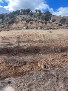
Figure 7: Soil Horizons Gypsum Colorado
Assigning soil orders can be accomplished by surveying soil properties such as color, texture, thickness of horizons, parent materials and other factors (Table 1). Table 1 displays a brief description of the twelve different soil types located around the United States. A great tool to use to understand soil characteristics is the USGS Web Soil Survey. This online tool has mapped and classified soils throughout the United States
Table 1: (below) for a brief overview of Soil Orders.
Learning Target
- Earth’s systems result in changes in climate. (HS-ESS2-4)
Resources Needed to Complete the Activity
- State Soils booklets include general information about the soil series, location,
importance, uses, organisms, limitations, management, formation, and ecoregions.
State Soils
- Soil Web Survey
The United States Department of Agriculture (USDA) Web soil survey website provides interactive map to allow users to explore the soil survey data for locations throughout the U.S. https://websoilsurvey.nrcs.usda.gov/app/- Use the menu to zoom to the location, enter the zip code, lat/long, or city name
Activity: Soil Postcards
- Use Colorado Soil Postcards. Select a "postcard" listing a location (cards have a photograph, zip code, latitude/longitude, and/or city name.)
Helpful Links
- Helps to find CLORPT attributes –Use this website to access the postcard locations. https://www.soils4teachers.org/state-soils/
- After you find CLOPT attributes use this to determine soil order–USGS soil orders
website:
- This site is easier
- https://www.lancaster.ac.uk/lec/research/soils-knowledge-base/twelve-soil-orders/
- This site is more technical
- Website on soil horizons https://www.youtube.com/watch?v=Kk7yarqfDoU
Rubric
|
|
1 |
2 |
3 |
4 |
|
CLOPT |
|
Half CLORT factors are identified
Attributes of CLORT factors are used without detailed supporting factors to determine a soil order(s).
|
All CLORT factors are identified
Attributes of CLORT factors are used to make a detailed rationale for determination of soil order(s) |
All CLORT factors are identified
Attributes of CLORT factors are used to make a detailed rationale for determination of soil order of both your location and Eagle County |
|
Site Identification |
|
Half of site attributes are identified
Only facts are listed not detailed
No technical language
Identify your location you picked |
All site attributes are identified
Detailed information
Use of technical language
Identify your location you picked |
All site attributes are identified
Detailed information
Use of technical language
Can compare and contrast your location to Eagle Country |
|
Mechanics |
|
Multiple issues |
No issues |
No issues |
|
Poster |
|
Not neat
Not colored
Not on correct paper
|
Neat/ organized
Colored(draw soil horizons and order classifications)
On correct paper |
Neat / organized
Colored
On correct paper
Second poster includes Eagle County |
Megan Blauwkamp
Iceland Study Abroad Presentation
Amy Brown
Iceland: The Land of Fire and Ice Presentation


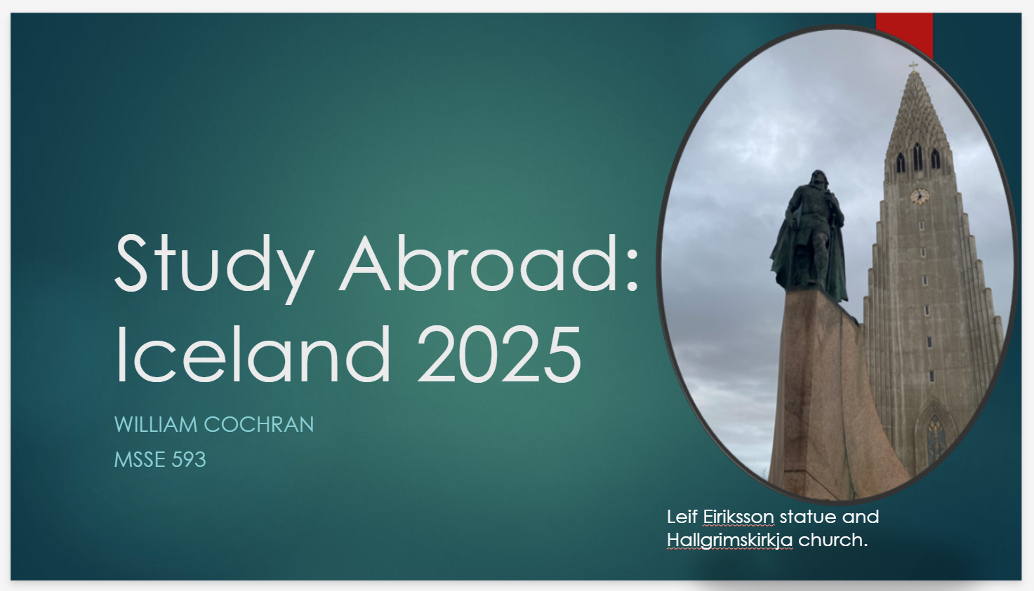
William Cochran
Study Abroad: Iceland 2025 Presentation

Rhi Flemming
Prezi presentation: Interconnected Iceland: An Exploration of Science and Culture
Michael Lee
Click here to view Iceland Montage Video
6-E Lesson Plan 1
Introduction
Human and animal genealogy living through civilization together is a testament to survival and a record of each other’s existence. Phenotypically both change and, at times with the naked eye, these traits can be seen right away with minimal inspection. But, studying the genotype of these organisms living hand-in-foot, hoof, or paw together is a much more reliable way of inspecting the lineage of time they have spent together. This lesson plan is to start teaching the Icelandic horses’ genetics coexistence with Mongolian peoples’ genetics through the passage of time. NOTE: This lesson is assuming students have had lessons or a unit on the genetics fundamentals.
Overview of 6-E lesson plan
Engage: Start the lesson with a photo of the Iceland horse and compare it with the Mongolian horse. The slide only shows two horses side-by-side with labels of their origin.
Explore: How did these two horses with similar phenotypes end up on opposite sides of the Earth?
Explain: What research have you uncovered that explains how these similar phenotypes show up on different parts of the world? What Punnett Square model will you show to trace this phenotypic link from one horse to the other?
Elaborate: What deep explanation using data will you use to show how these phenotypes showed up in Mongolia and Iceland?
Evaluate: How will you show that your model is applicable to other models in our classroom?
Extend/Electronic: What other factors make it possible to explain how these similar horse phenotypes showed up in Mongolia and Iceland?
Student behavior expectations:
- Students will write their notices (what they observe) and wonders (want to ask) about what they observe about the horses.
- Students will either work with another person or look inward and contemplate by themselves. Paired work means lots of loud talking and cooperating/negotiating as they write their notices and wonders.
- Students will choose who will speak on their behalf (rock-paper-scissors to choose will represent their group).
After two minutes have passed, bring the students to center on you. Ask students to share their thoughts.
Teacher behavior expectations:
- Listen for keywords or attempts at Tier-3 language use, whether correct or not.
- Briefly paraphrase/summarize what each group states in front of the students during this open forum.
- Daisy-chain thoughts from one group to another so a cohesive discussion occurs.
- Write down or type what the students are saying, particularly, attempts at Tier-3 vocabulary.
Day 1: Compare and contrast Icelandic horses with horses that were bred to produce it.
- Show a photo of an Icelandic horse. Have students notice and wonder about this breed with the guiding task and question: Create a Notice and Wonder chart. What do you observe about this horse and what do you wonder about this breed? Provide 5 minutes to write their observations.
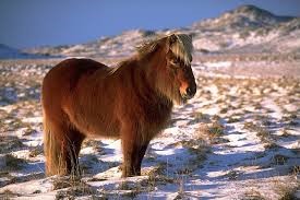
An Icelandic horse
- Have students share their Notices and Wonders about these two horses with each other (5 min) then share aloud with the entire class (5 min).
Teacher’s behavior note: During their partner share, listen to key words and concepts. This will help you get ready to lead the class discussion. During the class share, repeat good ideas, and with ones that are not so great or way ahead of the discussion, say “That’s a possibility. Let’s put that to the side and we’ll come back to it. I promise.”
- Anticipate the following notices:
- It has a thick pelt, long mane, short legs, stocky body, long tail, it could be a wild horse, it lives in a cold region, Iceland is cold so there’s not a lot of vegetation to eat and that’s why it’s small (diet is a representation of its access to a food source).
- Anticipate the following wonders:
- How tall is it? Are there a lot of them in Iceland? Are they the same color as the one in the photo? Are there Icelandic horses that are bred by people?
- Show the following model and say, “You stated observations and questions about the phenotypes of the Icelandic horse. With all phenotypes, there is an origin. The traits the horse possesses must come from somewhere.”
?
'Origin animal' of
the Icelandic horse
----????---->
An Icelandic horse
Present guiding questions ‘a’ and ‘b’. Allow seven minutes to discuss AND write their answer-thoughts about the two questions. Create a five-minute discussion with the class.
- What phenotypes will the origin animal of the Icelandic horse have?
- b. What other data will you need from me to confirm your new wonders about the origin problem?
- Anticipate the following notices and wonders:
- The origin horse could have similar phenotypes with the Icelandic horse.
- How different will the origin animal be compared to the Icelandic horse? Will the origin horse be from someplace far away? If the origin horse is from Iceland, how different could this origin horse be from the Icelandic horse?
Confirm the ideas that mention the phenotypes and vocabulary that explains possible characteristics (biological and geographical) related to the Icelandic horse.
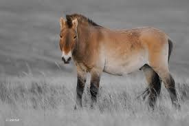
- 4. Show a photo of a possibly related horse to an Icelandic horse.
 ------------------------------------>
A Mongolian horse An Icelandic horse
Say, “Notice that the ‘Origin animal’ of the Icelandic horse box has been replaced with a Mongolian horse.”
Ask: What are some notices and wonders you can write down about the connection between the Mongolian horse and the Icelandic horse?”
- Notices and wonders could be similar to the previous notices and wonders during the ‘Origin animal of the Icelandic horse’.
- The Mongolian horse has similar phenotypes to the Icelandic horse, but slightly different.
- How did the Mongolian horse become related to the Icelandic horse? Was the Mongolian horse transported to Iceland or vice versa? Since there are differences, how did those differences occur between the two horse species?
Say and ask: To confirm your observations, what further data (kind and type of information) do you need from me to confirm your observations:
- While walking around listen for the following student ideas:
- Graphs or infographic to show the differences and relationship between Mongolian and Icelandic horses.
- Data table that shows the transition from one organism to another.
After students do their notice and wonders between Mongolian horse and Icelandic horse, present the following online article:
Icelandic Horses and Mongolian Descendants
https://trishnicholsonswordsinthetreehouse.com/2019/07/24/icelandic-horses-and-mongol-descendants/
Do a Close Reading with the students. Close reading is when students follow the teacher’s voice as he/she reads aloud. Students follow by highlighting facts or information that will help them make decisions about future activities. In this case, say, “With your highlighter or pen, please underline information that will help you make the connection between Mongolian and Icelandic horses”. Suggested time to read aloud to students is five to six minutes.
After the close reading…
Ask, “how would you model Mongolian and Icelandic horse similarities and their differences at the same time?”
Give them 10 minutes to talk about and create a rough model.
Remind students a model has the following items:
- How many variables did you observe?
- A variable to measure what you want to find out.
- 3. A variable of what you want the result to be.
- When the variables are interacting, how will you draw it in the model to show other what the connections are?
After five minutes, do a class discussion about what model they decided to create and show as they explain it. Choose two to three groups to share their model and thoughts on the process.
Verbally acknowledge the elements needed to create a certain model: the Punnett Square.
Those elements are:
-ordered organization of how the variables move.
-the model’s variables can be rearranged to show change or no change.
-the model can be applied to different variables but produces results that are similar when used with other variables.
-the results (dependent variables) can be explained by tracing back to the independent variables.
Ask, “What part of a gene represents what the organisms is or will be?” (allele)
Say, “Drawing alleles on genes looks good when standing still, but to see it work, what model will you create to show how these alleles express themselves?”
Refer students back to the guidelines and have them redesign their model to include the elements just mentioned.
Have students work on this task for the next 8 minutes.
Reference:
Nicholson, T., (n.d.). Icelandic Horses and Mongol Descendants. Words in the Treehouse.
https://trishnicholsonswordsinthetreehouse.com/2019/07/24/icelandic-horses-and-mongol-descendants/
6-E Lesson Plan 2
Introduction
Human and animal genealogy living through civilization together is a testament to survival and a record of each other’s existence. Phenotypically both change and, at times with the naked eye, these traits can be seen right away with minimal inspection. But, studying the genotype of these organisms living hand-in-foot, hoof, or paw together is a much more reliable way of inspecting the lineage of time they have spent together. This lesson plan is to start teaching the Icelandic horses’ genetics coexistence with Mongolian peoples’ genetics through the passage of time. NOTE: This lesson is assuming students have had lessons or a unit on the genetics fundamentals.
Overview of 6-E lesson plan
Engage: Refer to the previous lesson about students creating their model to reflect the genetic connection between Mongolian and Icelandic horse.
Explore: How would will students model that two horses with similar phenotypes end up with a horse that carries similar characteristics?
Explain: What Punnett Square model will you show to trace this phenotypic link from one horse to the other?
Elaborate: What deep explanation using data will you use to show how these phenotypes showed up in Mongolia and Iceland?
Evaluate: How will you show that your Punnett Square model is applicable to other models in our classroom?
Extend/Electronic: What other factors make it possible to explain how these similar horse phenotypes showed up in Mongolia and Iceland?
Note: This lesson about Punnett Squares is based on this online lesson from Oak National Academy:
Student behavior expectations:
- Students will write their notices (what they observe) and wonders (want to ask) about what they observe about their model to show the genes that are passed on to each other?
- Students will either work with another person or look inward and contemplate by themselves. Paired work means lots of loud talking and cooperating/negotiating as they write their notices and wonders.
- Students will choose who will speak on their behalf (rock-paper-scissors to choose will represent their group).
After a certain time has passed, bring the students to center on you. Ask students to share their thoughts.
Teacher behavior expectations:
- Listen for keywords or attempts at Tier-3 language use, whether correct or not.
- Briefly paraphrase/summarize what each group states in front of the students during this open forum.
- Daisy-chain thoughts from one group to another so a cohesive discussion occurs.
- Write down or type what the students are saying, particularly, attempts at Tier-3 vocabulary.
Day 1: Compare and contrast Icelandic horses with horses that were bred to produce it.
- Remind students of what they learned from the connection between a Mongolian horse and an Icelandic horse. Have an open discussion about what they learned and select two to three students to move the lesson along. Show the images below to guide the reminder discussion along.
------------------------------------>
A Mongolian horse An Icelandic horse
- Introduce the vocabulary that will help students understand the mechanics of a Punnett Square: Gamete, Genotype, Ratio, Probability. Briefly explain each without giving the definition of each. Students will later find the definition and provide examples to support their understanding of each definition.
Teacher’s behavior note: Be aware of three misconceptions during this learning period:
- A gamete has two alleles (Males X and Y, while Females X and X);
- Punnett Squares has too many alleles for gametes;
- Only four offspring will be produced and that Punnett Square is 100% correct in saying these are the results of the offspring.
- 3. Show the Lesson video from the link. Say, “Earlier, you stated observations and questions about the phenotypes of the Icelandic and the Mongolian horse. With all these phenotypes, it needs to be expressed, and a Punnett Square will model that expression by the allele.
- 4. Present guiding questions ‘a’ and ‘b’. Allow seven minutes to discuss AND write their answer-thoughts about the two questions. Create a five-minute discussion with the class.
- What phenotypes do the Mongolian and the Icelandic horse have?
- b. How will you show these phenotypes as alleles in the Punnett Square?
- Anticipate the following notices and wonders:
- According to the video, there needs to be two parents to provide the alleles.
- Which alleles will we use to show how the Icelandic horse was born?
Confirm the ideas that mention the phenotypes and vocabulary that explains possible characteristics (biological and geographical) related to the Icelandic horse and can be used in the Punnett Square.
- 4. Show a photo of a possibly related horse to an Icelandic horse.
------------------------------------>
A Mongolian horse An Icelandic horse
Say, “Let’s slow down a bit. The following worksheet will help you work through alleles being hypothetically exchanged to produce certain offspring.”
Provide 10 minutes to work through the worksheet provided by the Oak National Academy website
After 10 minutes have passed, ask: What are some skills you can apply to show how alleles are passed on from one generation to the next?
- Notices and wonders could be:
- Since the Icelandic horse and the Mongolian horse aren’t the same, another allele from a different type of horse would be needed.
- How would we put that on the Punnett Square? Which allele would we use from two parent horses to produce an Icelandic horse?
Say and ask: To confirm your observations, let’s work together and produce some Icelandic horse offspring.
- Walk the students through one type of allele exchange.
- Model and explain the steps and the set up from Punnett Square grid to offspring result.
After students follow what was modeled, say, “It’s your turn. First, list phenotypes the Mongolian and Icelandic horse have in common, and use those phenotypes to produce your offspring genotypes.
Remind students to go back to their previous lesson and use the article from the previous lesson to select phenotypes. Allow students to look up horse breeds mentioned in the article to see what the horses looked like.
Icelandic Horses and Mongolian Descendants
https://trishnicholsonswordsinthetreehouse.com/2019/07/24/icelandic-horses-and-mongol-descendants/
- Have students work on multiple Punnett Squares for the parents’ chosen phenotypes of the Icelandic horse. Provide 10 minutes to create as many Punnett Squares to represent the possible phenotypes of the Icelandic horse as a result of the Mongolian horse breeding with another horse breed.
Teacher behavior:
- Walk around and monitor for student work. Students should follow the single allele model of the Punnett Square.
- If there are students you plan to embark on polygenic allele, then carefully monitor their work to ensure there is no confusion on representing how the alleles are written or expressed inside the offspring grids.
References:
Nicholson, T., (n.d.). Icelandic Horses and Mongol Descendants. Words in the Treehouse.
https://trishnicholsonswordsinthetreehouse.com/2019/07/24/icelandic-horses-and-mongol-descendants/
Oak National Academy. (n.d.). Models of single-gene inheritance: Punnett squares.
Readings Analysis and Discussion
Michael LeeMSSE 593 Study Abroad Iceland2024.04.19
Sæmundson, K., Sigurgeirsson, M.A., & Friðleifsson, G.Ó. (2018). Geology and structure of the Reykjanes
volcanic system, Iceland. Journal of Volcanology and Geothermal Research, 391(2020), 1-13
https://doi.org/10.1016/j.jvolgeores.2018.11.022
This article describes Reykjanes, better known as “the southwestern tip of the Reykjanes Peninsula, a lava covered area of 25 km2. The introduction covers the four main types of rift and transform structures. The authors prefer “postglacial rather than Holocene” because the latter refers to a “fixed beginning” and “Reykjanes became ice-free 4000-5000 years before the Holocene” (p.1).
To describe Reykjanes’ geology, the premise is that “volcanic systems are the building blocks of spreading zones” (p.2). 18.6 mm/y describes the ocean floor reversal pattern’s rate of spreading and 18-20 mm/yr across “Iceland’s combines Western and Eastern Volcanic zones” (p.2).
From our Iceland field studies, the use of this geology is important. Due to the trans-tensional zones, which are different from most volcanic system with their subparallel run with the plate boundary to form volcanic rift zones, the trans-tensional zone run provides “low to medium temperature geothermal systems” (p.2).
After drilling six boreholes through 100-200mm fresh rock in the northwest of the Peninsula, “shells dated from sediment immediately below flow foot breccias at 70-80 m depth in the boreholes” (p.2) while going farthest east and southwest “yielded an age of about 14,500 years” (p.4).
A figure provided by the authors on p.3 provides a map of aeromagnetic intensity and I wonder if my magnetic sensor would’ve provided quantitative data that matches the aeromagnetic map and would it be comparable to Jejudo’s magnetic intensity?
Another reference to our Iceland field studies, tephrochronology was raised, and according to Sæmundson et al it’s “based on eight distinctive ash layers and a number C-14 datings” that can measure volcanic activity on the Peninsula for the last 4500 years (p.5).
Speaking of volcanic activities, microearthquake swarms registered over the 40 years “gradually extend the trace of the plate boundary” and fill into gaps which explains the seismic imprint of the fracture zone and discontinuous depths (p.5).
Gudmundsson, M.T., Larsen, G., Höskuldsson, Á., & Gylfason, Á.G. (2008). Volcanic hazards in Iceland. Jökull,
58(1), 251- 268 DOI:10.33799/jokull2008.58.251
Just like the title implies, the authors present the different hazards with the appropriate hazard throughout the paper. First, a little background about Iceland’s geography and its influence on its inhabitants. It’s sparsely populated with “no permanent settlements in the interior highlands” (p.251). The population is mainly on the coast, while “70% of the 300 thousand residents (at the time of the article) living in the greater Reykjavik area” (p.251). Iceland has volcanic zones which have systems of a central volcano and fissure swarm that extends “tens of kilometres along strike in both directions away from the central volcano” (p.252). These central volcanoes have small eruptions (<0.1 km2) and produce basalts. When the volcanic events are large, they are fires, which are a “series of eruptions occurring along the same fissure over a period of several months or years” and produce “79% of the basalt in the last 1130 years…intermediate compositions accounting for 16% and silicic eruptions for 5%” (p.253).
Tehpra fallout is determined by “the type, intensity and magnitude of the eruption” along with the location of people are located will add to the damage and harm caused by the tephra. In terms of hours and patience applied to Icelanders, tephra fallout can last an hour, several hours, or day and weeks, depending on the type of columns or fissures the fallout’s origin. The authors reference Hekla and among its 18 eruptions, “in 1104, deposited a 20 cm thick tephra layer 30 km from Hekla and devastated farms up to 70 km from the volcano” (p.256). An impact on agriculture is felt, but the travel to and away from Iceland, including “parts of the North Atlantic” are no exception (p.257).
Lightning from phreatomagmatic eruption columns have been witnessed and documented from the Katla eruptions in 1755, and according to the authors, when referencing the Grímsvötn eruptions lightning is not such a threat “far from populated area and the moderate size of past eruptions” (p.257).
With pollution, tephra particles carry chemical compounds into the water and grazing lands. Hekla is referenced as “magma rich in halogens, in particular fluorine” (p.257). Fluorosis kills livestock, fish, and humans. All of these are connected to famine from fluorine and has been recorded as far as 1693.
Pyroclastic density currents “are not prominent” because of the basalt in Icelandic volcanoes. When referencing time, the authors refer to the Quaternary Period and the lack of silicic pyroclastic flow deposits is due to pyroclasts depositing on glaciers during glacial periods so they aren’t preserved. Second, “glacial erosion may have removed interglacially-formed pyroclastic deposits” (p.258). In terms of harm to daily life, “pyroclastic flows can be the most devastating and deadly hazard in explosive eruptions”, reaching inhabited areas in Iceland is low (p.259).
Jökulhlaups, translated as glacial bursts or runs, are “[t]he most common hazards related to volcanic and geothermal activity in Iceland…majority coming from glaciers of Vatnajökull and Mýrdalsojökull” (p.259). There are two types of volcanic-related jökulhlaups. First, volcanic eruptions produce the thermal energy to create the meltwater. Second, meltwater produced from geothermal “accumulates in a subglacial lake” then drained at semi-regular intervals when the lake reaches a critical value” (p.259).
Freysteinn, S., Einarsson, P., Hjartardóttir, Á.R., Drouin, V., Jónsdóttir, K., Árnadóttir, T., Gerisson, H., Hreindóttir,
S., Li, S., & Ófeigsson, B.G. (2018). Geodynamics of Iceland and the signatures of plate spreading.
Journal of Volcanology and Geothermal Research, 391(2020), 1-16
DOI:10.1016/j.jvolgeores.2018.08.014
Reading the rocks at a plate boundary is useful, where ‘0’ at the plate boundary to 15 million years at the “eastern and western extremities of Iceland” (p.1). Currently active plate boundaries have a series of volcanic and seismic zones created by the interaction between the Mid-Atlantic Ridge and Iceland’s mantle plume. Volcanic zones are about 32 volcanic systems and consist of a central volcano with a caldera and fissure swarms. According to the authors, along with this description of a volcano zone, Iceland’s high volcanic activity is due to “excessive mantle melting under Iceland due to interaction of a mantle plume and mid-oceanic spreading ridge” (p.2).
Iceland is determined by the North American and Eurasian plates and the different areas of the plate boundary may “deviate considerably…by the presence and relative movements of the Hreppar Microplate” (p.2).
To continue the topic of Iceland’s volcanic zones and systems, it’s mostly made up of basalts and divided into four stratigraphic groups: Upper Tertiary (>3.3 m.yr), Upper Pliocene/Lower Pleistocene (better known as the Plio-Pleistocene) of 0.8-3.3 m.yr, the Upper Pleistocene (<0.8 m.yr) and the Postglacial. According to the color-coded geological map of Iceland provided by the authors, the pattern of oldest along the northern and eastern coast while the youngest going toward the interior of the island.
The authors provide an equation of maximum horizontal stress (Eh max) and it relationship to eruptive fissures and fissure swarms. When visualizing the graph Eh max = 90o – ½ tan-1(cota)
After putting the equation into a free, online graphing program called Desmos, here are the results:
Upon consulting my math teacher colleague, and playing around with the equation, we discovered that 90 degrees is a constant and the ½ could be placed to keep the measurement in control to stay within the parameters. We surmised the angles on the graph represent the eruptive fizzures and as the alpha is changed, it represents the stress on the fizzure and close to eruption. By placing our cursor on the appropriate x-value on the x-axis, and tracing upward, we get a certain y-value. By cross-referencing with the paper, the values check out. We further surmised this model is used as a pre-warning system for inhabitants in Iceland along those X and Y map coordinates.
Sæmundson, K., (2023, February). Outline of the geology of Iceland. Jökull, 29, 7-28,
DOI:10.33799/jokull1979.29.007
According to Sæmundson, eastern Iceland has “confirmed a minimum of 4km thickness in lava pile” (p.7). It consists of 80-95% basalt and has an acidic chemistry. As a result, lavas and intrusions are 60-70% acidic. Calderas are discussed and are of interest to me because a part of Jeju Island holds a caldera. Lava piles grew as “lenticular units from elongate volcanic systems which included swarms of dykes and fissures usually localized about central volcanoes” (p.7). With acid and intermediate rocks among the basalt, these lenticular units become thicker in those area of the central volcano, which are characteristics of a caldera.
During our Iceland field studies, hot spots were a common topic. According to the author, hot spots are used to explain the “unusual elevations found across the North Atlantic in the Iceland region” (p.26). These unusual elevations is because of an “anomalous mantle underneath Iceland with lower average densities and higher temperature than the surrounding region” (p.26). Furthermore, Iceland’s crust is “more than twice as thick as the normal oceanic crust” (p.26).
Tegan Mortimer
Iceland: Land of Fire and Ice, Shaped by Resilience Presentation


 Patrice Rex
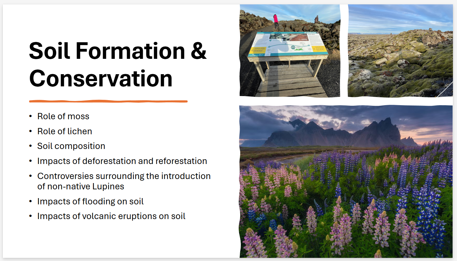
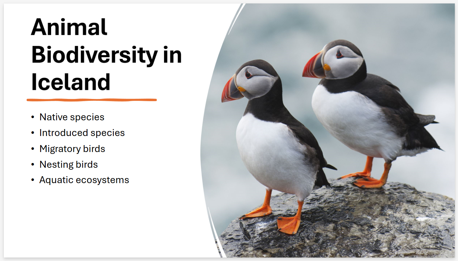
Icelandic Ecosystems Presentation
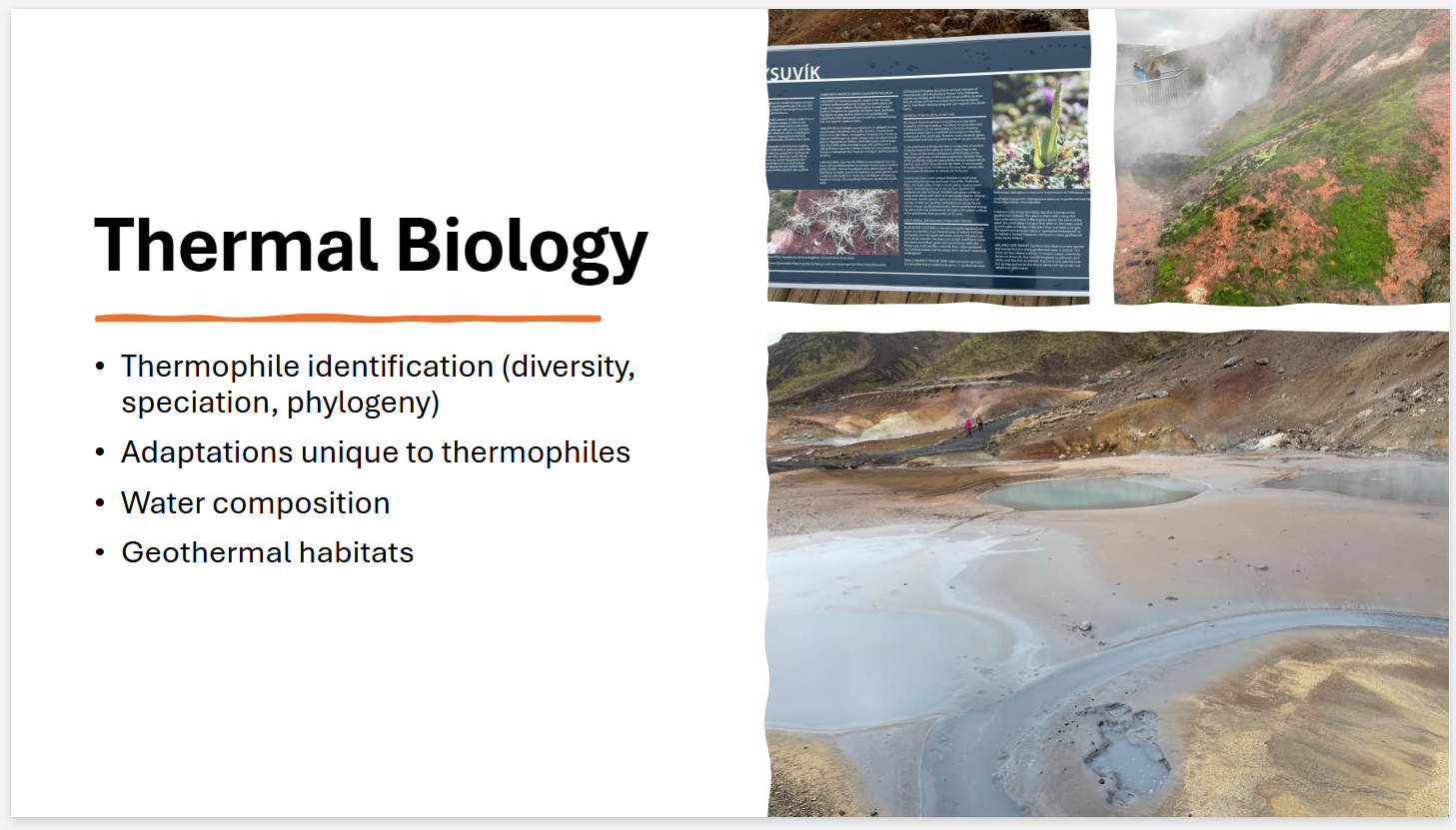
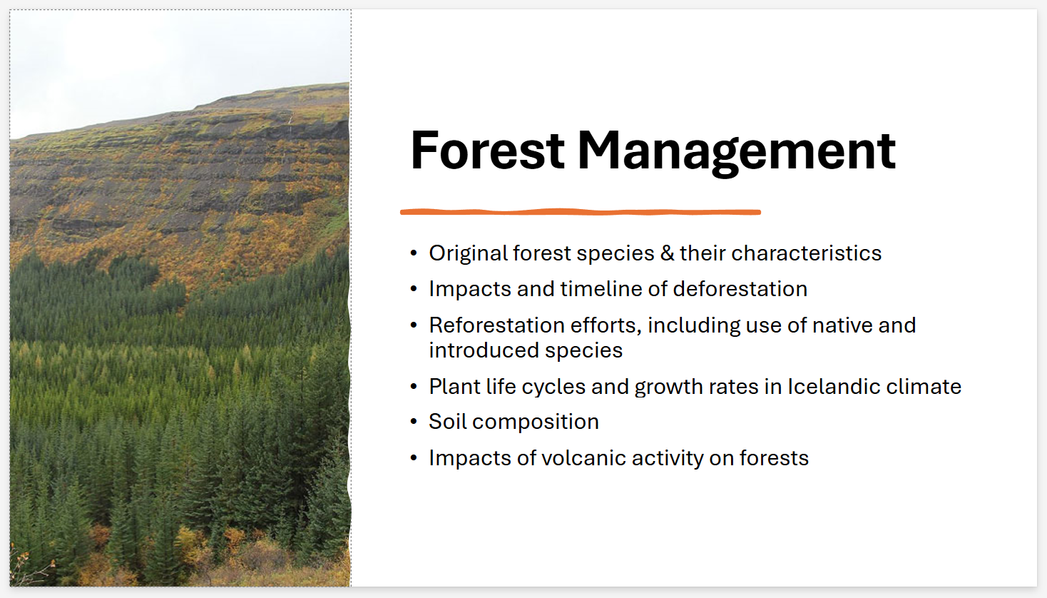
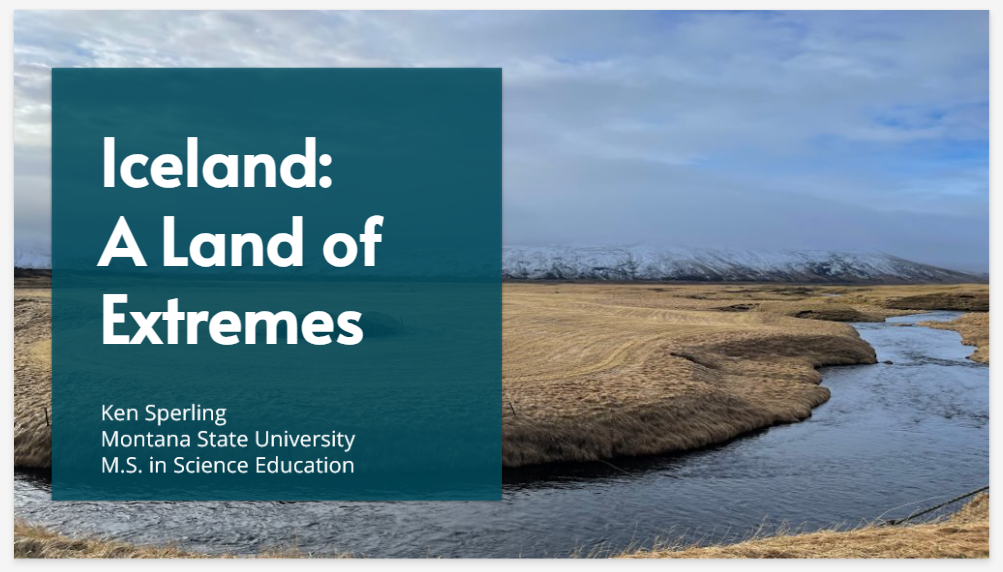
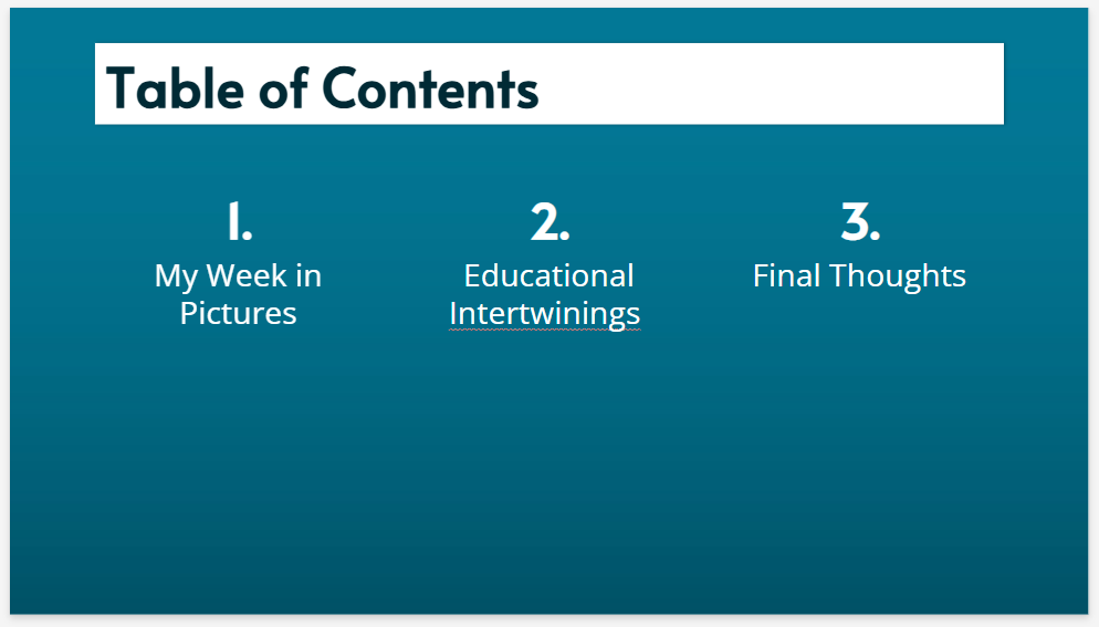
Ken Sperling
Iceland: A Land of Extremes Presentation


Donna Tully
Exploring the Land of FIre and Ice: Iceland-Through the Lenses of Chemistry & Biology Presentation

Dan Vasquez
Click this link to view Google Earth presentation.
Annie Wentz
Adapatability of Icleanders in Response to Changing Environmental, Geological, Sociologica, and Economic Factors Presentation
Cheyenne Winchester
MSSE 593 - Iceland Expedition Presentation